As of August 30, 2016, high eruptive activity is observed on 28 volcanoes in the world.

The main event of the current week was a series of earthquakes with a magnitude of up to 6.2 , shaking the Italian regions of Lazio and Umbria since Tuesday August 23, 2016.
The tremors are tectonic in nature, but it is worth noting that on the territory of Lazio and in neighboring Campania there isseveral potentially active volcanoes, which may be susceptible to the shaking of the earth's mountain. This is Collie Albanion the outskirts of Rome, and the Vulsini caldera complex, which, according to historical chronicles, last erupted in 104 BC.
After a devastating earthquake of magnitude 6.0 (according to other sources, 6.2) in Central Italy on August 24, INGV seismologists recorded a total of 2553 localized seismic events.

129 earthquakes were between magnitude 3.0 and 4.0; 12 tremors - with a magnitude from 4.0 to 5.0, one seismic event occurred with a magnitude of 5.4.
Activity at Mount Etna has generally decreased slightly in recent weeks and tremors are currently low. The emissions of hot, incandescent gases and ash did not stop, but together with weak Strombolian-type activity from the new vent and the Voragine crater, they became less pronounced. Sporadic ash eruptions were observed intermittently.
Klyuchevskoy (Kamchatka, Russia).
An explosive eruption continues at the summit with the release of volcanic bombs from the summit crater and strong steam and gas activity in two volcanic centers. Throughout the week, a large thermal anomaly was observed in the Klyuchevskoye area.
On August 28, 2016, ash was released to a height of 6 km above sea level, and the ash plume stretched northeast of the volcano. A lava flow about 1.5 kilometers long moved along the southwestern slope of the giant.

Klyuchevskoy volcano is the most active and powerful basalt volcano in the Kuril-Kamchatka volcanic region. It is located in the Klyuchevskaya group of volcanoes in the northern part of the Central Kamchatka Depression on the right bank of the Kamchatka River. The closest settlement to the volcano is the village of Klyuchi, which is located approximately 30 km from the giant. The height of Klyuchevsky volcano is about 4850 m. It is the highest active volcano in Europe and Asia.
The previous eruption of Klyuchevsky volcano began on January 1 and ended on March 24, 2015. The current volcanic eruption began on April 3.
Bagan Volcano erupts again in Papua New Guinea.
Bagan Volcano is located on the island of Bougainville, part of the province of the same name, in Papua New Guinea.
Bagana has the shape of a lava cone, 1750 meters high. Located west of the volcano Billy Mitchell. It is a young active volcano and has been erupting continuously since the 18th century. The eruptions consist of lava and pyroclastic flows.
Ash emissions are occurring again at the Bagan Volcano in Papua New Guinea, producing an ash plume approximately 2.1 km high. The ejection drifted west from the giant on August 29, and no negative consequences of the eruption were recorded.

The latest satellite imagery shows a narrow stream of mostly gas and possibly some ash 70 km west of Bougainville Island. A moderate thermal hot spot is visible in Moody's data and has increased recently. This suggests that the volcano's activity has increased recently. Bagan Volcano is located on the island of Bougainville in the province of the same name in Papua New Guinea.
Since 1842, the volcano has made its presence known more than 30 times. The last emission of volcanic ash from the volcano occurred between August 1-7, 2012 and reached a height of 3000 meters; the ash plume traveled northwest from the volcano, covering a distance of 37 kilometers.
Colim volcano eruptionA.
The Colima volcano in Mexico, also known as the “Volcano of Fire,” on Monday, August 29, ejected a column of gas and ash to a height of about 2.4 thousand meters.The volcano is part of the so-called "Pacific Ring of Fire", an area around the perimeter of the Pacific Ocean that contains the majority of active volcanoes and many earthquakes. Mexico's most active volcano, it has erupted more than 40 times since 1576. Cordillera mountain system, the form of the volcano is stratovolcano. Consists of 2 conical peaks; the highest of them (Nevado de Colima, 4,625 m) is an extinct volcano, covered with snow most of the year. Another peak is the active Colima volcano, or Volcán de Fuego de Colima (“Fire Volcano”), 3,846 m high, called the Mexican Vesuvius.
In total, there are more than 3 thousand volcanoes in Mexico, but only 14 of them are considered active.
As stated in the report of the ALLATRA SCIENCE community of scientists:
“Large-scale natural disasters that occur cyclically on the planet have already happened more than once in the history of the Earth and human civilization. But what lessons does this scientific knowledge, which testifies to past universal planetary tragedies, teach? ... The consequences and troubles that planetary cataclysms bring go far beyond the “hotbed” individual state and, one way or another, affect all inhabitants of the Earth. A sharp increase in seismic and volcanic activity leads to instant catastrophic consequences in certain regions. Entire states disappear from the face of the Earth, people die, many are left homeless and without a means of subsistence, famine and large-scale epidemics begin...
People need to throw away all frameworks and conventions, they need to consolidate here and now. Nature does not look at ranks and ranks when it unleashes its thousand-year wrath, and only the manifestation of true community between people, based on human kindness, can give humanity a chance to survive...”
Volcanoes are individual hills above channels and cracks in the earth’s crust, through which eruption products are brought to the surface from deep magma chambers. Volcanoes usually have the shape of a cone with a summit crater (from several to hundreds of meters deep and up to 1.5 km in diameter). During eruptions, a volcanic structure sometimes collapses with the formation of a caldera - a large depression with a diameter of up to 16 km and a depth of up to 1000 m. As the magma rises, the external pressure weakens, associated gases and liquid products escape to the surface and a volcanic eruption occurs. If ancient rocks, and not magma, are brought to the surface, and the gases are dominated by water vapor formed when groundwater is heated, then such an eruption is called phreatic.
Active volcanoes include those that erupted in historical times or showed other signs of activity (emission of gases and steam, etc.). Some scientists consider active volcanoes that are reliably known to have erupted within the last 10 thousand years. For example, the Arenal volcano in Costa Rica should be considered active, since volcanic ash was discovered during archaeological excavations of a prehistoric site in this area, although for the first time in human memory its eruption occurred in 1968, and before that no signs of activity were shown.
Volcanoes are known not only on Earth. Images taken from spacecraft reveal huge ancient craters on Mars and many active volcanoes on Io, a moon of Jupiter.
Distribution of volcanic activity
The distribution of volcanoes across the surface of the globe is best explained by the theory of plate tectonics, according to which the Earth's surface consists of a mosaic of moving lithospheric plates. When they move in the opposite direction, a collision occurs, and one of the plates sinks (moves) under the other in the so-called. subduction zone, where earthquake epicenters are located. If the plates move apart, a rift zone forms between them. Manifestations of volcanism are associated with these two situations.
Subduction zone volcanoes are located along the boundaries of moving plates. The oceanic plates that form the floor of the Pacific Ocean are known to subduct beneath continents and island arcs. Subduction areas are marked in the topography of the ocean floor by deep-sea trenches parallel to the coast. It is believed that in zones of plate subduction at depths of 100-150 km, magma is formed, and when it rises to the surface, volcanic eruptions occur. Since the plunging angle of the plate is often close to 45°, volcanoes are located between the land and the deep-sea trench at a distance of approximately 100-150 km from the axis of the latter and in plan form a volcanic arc that follows the contours of the trench and coastline. There is sometimes talk of a “ring of fire” of volcanoes around the Pacific Ocean. However, this ring is intermittent (as, for example, in the region of central and southern California), because subduction does not occur everywhere.
Rift zone volcanoes exist in the axial part of the Mid-Atlantic Ridge and along the East African Rift System.
There are volcanoes associated with “hot spots” located inside plates in places where mantle plumes (hot magma rich in gases) rise to the surface, for example, the volcanoes of the Hawaiian Islands. It is believed that the chain of these islands, elongated in a westerly direction, was formed during the westward drift of the Pacific Plate while moving over a “hot spot.”
Now this “hot spot” is located under the active volcanoes of the island of Hawaii. Towards the west of this island, the age of the volcanoes gradually increases.
Plate tectonics determines not only the location of volcanoes, but also the type of volcanic activity. The Hawaiian type of eruptions predominates in areas of “hot spots” (Fournaise volcano on Reunion Island) and in rift zones. Plinian, Peleian and Vulcanian types are characteristic of subduction zones. There are also known exceptions, for example, the Strombolian type is observed in various geodynamic conditions.
Volcanic activity: recurrence and spatial patterns.
Approximately 60 volcanoes erupt annually, and about a third of them erupted in the previous year. There is information about 627 volcanoes that have erupted over the past 10 thousand years, and about 530 in historical time, and 80% of them are confined to subduction zones. The greatest volcanic activity is observed in the Kamchatka and Central American regions, with quieter zones in the Cascade Range, the South Sandwich Islands and southern Chile.
Volcanoes and climate . It is believed that after volcanic eruptions, the average temperature of the Earth’s atmosphere drops by several degrees due to the release of tiny particles (less than 0.001 mm) in the form of aerosols and volcanic dust (while sulfate aerosols and fine dust enter the stratosphere during eruptions) and remains so for 1 -2 years. In all likelihood, such a decrease in temperature was observed after the eruption of Mount Agung on Bali (Indonesia) in 1962.
On planet Earth, evidence of ongoing processes within the earth's crust manifests itself daily and in different ways. During our travels, we visited a number of active and extinct volcanoes around the world, and also visited Yellowstone National Park, located in the crater of a supervolcano, where today there are many active geothermal springs and geysers. All these places are united by the fact that active processes occurring in the earth’s crust today or hundreds of millions of years ago influenced and continue to influence our planet and the climate on it. They are the cause of changes in flora and fauna, as well as a catalyst for evolution. Let's try to briefly understand what volcanic activity causes to our planet, as well as what post-volcanic phenomena occur after eruptions. 
Volcanoes themselves are not as dangerous as we used to think. We must be wary first of all of the various emerging accompanying phenomena during volcanic eruptions:
- Volcanic phenomena- occur simultaneously with volcanic eruptions.
- Rock avalanches- are formed during vertically directed explosions and contain fragments of previous and freshly erupted lavas.
- Scorching clouds- have different origins, have high mobility (up to 90 km/h) due to hot gases (up to 900 degrees) emitted by ash particles. They are able to burn in a short time everything that comes their way.
- Mud and water flows are formed during the rapid melting of snow caps and glaciers on the slopes of volcanoes during their eruption.
- Post-volcanic phenomena- arise and occur after volcanic activity subsides, and are associated with the release of volcanic gases, numerous gas-steam jets and hot water with superheated steam.
- Release of volcanic gases - fumaroles. They come in dry high-temperature varieties (over 500 degrees), sulphurous (hydrogen sulfide) - solfataras (temperature from 100 to 300 degrees) and cold carbon dioxide - mofets (temperature below 100 degrees)
- Thermal Baths— underground sources of hot water in areas of volcanism. The waters in them are mineralized with various impurities: chloride, carbonate, sulfate, mixed. Often, deposits of siliceous or calcareous tuffs occur around such sources. Thermal baths are common in Kamchatka, Iceland, the Baikal region, the Caucasus and Italy.
- Geysers- these are hot springs consisting of water and steam, which periodically throw water with superheated steam up to a height of hundreds of meters. The most famous valleys of geysers are located in Kamchatka, New Zealand, Iceland, the USA and Japan. Geysers are usually found in fault zones in the earth's crust. The water in them contains sodium chloride impurities with a mineralization of about 2.5 grams per liter and is characterized by a varied composition. Hot water, erupting from the geyser under the influence of steam, carries a large amount of dissolved minerals - mainly silicon oxide, which are deposited on the walls of the geyser and around its outlet channel - the vent, forming a funnel-shaped tube on the surface of the Earth. The resulting deposits form terraces around the geyser in the form of deposits or large cones - geyserite structures.
- Mud volcanoes- cone-shaped hills of different diameters and heights formed by loose sediments. Due to the accumulation of gases and superheated water vapor coming from below through cracks in the earth's crust, liquid mud erupts. If the mud is so liquid that it cannot harden over time, and new eruptions only support the process of mud formation and mixing, then the result is a mud cauldron.
Because of its unpredictability, it greatly influences the processes of normal life on earth. Everyone is well aware of examples of volcanic lava flowing out and its destructive properties for all living things around. We also know firsthand what happens to the atmosphere when clouds of ash rise into the air; we immediately recall the eruption of the Eyjafjallajökull volcano in Iceland, which stopped air traffic with many countries for several weeks, resulting in a real transport collapse in Europe.
- Interesting fact: few people know that the islands were formed at the site of volcanic activity; most of them are of volcanic origin and they are located on the tops of ancient underwater volcanoes.
Also, in addition to the most famous volcanic phenomenon - a volcanic eruption, there are also lesser-known volcanic and post-volcanic phenomena that occur in our lives. We are talking about mud flows, geothermal springs, thermal baths and geysers. I will tell you more about them.
Such places usually make the biggest impression on a trip, because they are completely different from the usual landscapes. They are simply different to perceive, and that makes the experience of personal acquaintance with them valuable. Therefore, we are glad that we visited some of the valleys of geysers in person, and plan to see others someday! And now we will tell you about volcanic activity and post-volcanic phenomena in more detail and illustrate them with photographs from our travels.

Mud volcano at an altitude of 4300 meters on a high plateau in Bolivia


Fumarole - the release of volcanic gases to the surface of the earth

The Bolivian Altiplano is so cold that the water freezes a short distance from the geothermal spring.
Mud flows descend from the slopes of active volcanoes and contain large amounts of loose rock fragments covering these slopes. Most volcanic mud flows are cold, but some are hot.
A mud flow occurs when a large mass of water somehow falls on the slope of a volcano covered with a layer of debris. This may be the result of a geyser eruption or for some other reason, such as a sudden release of water from a crater lake. The largest of these lakes is located in Oregon -. Its volume is about 17.5 cubic kilometers, and in depth it is the first in the United States - 594 meters. If an explosion occurs under such a lake and some of the water splashes onto the slope through a crack in the crater, or rising above the upper edge of the volcanic funnel, this will cause a strong mud flow.

Facts about mud flows
- In a study in Washington State, USA, it was discovered that the sediments around it were left by prehistoric mud flows formed as a result of lava splashing due to the rapid increase in the volume of meltwater from the slopes of the volcanic crater, when lava flows began to move along the slope and came into contact with glacier. The mud flows formed as a result of the eruption of Mount Rainier are among the largest ever explored in the whole world and their volume reaches 2 billion cubic meters!
- Some of the mud flows are formed as a result of avalanches or ash flows mixing with mountain rivers. As a result of steam explosion, the surface layer is destroyed and a mud flow is formed.
- Mud can also form when ash is released into the atmosphere and comes into contact with rain clouds. As a result, precipitation covers the vegetation in such a thick layer that tree branches break, and weakly strengthened soil is subject to movement.
- The debris deposited by volcanic mud flows hardens like concrete when it cools and dries.
- Most volcanic mud flows contain a significant proportion of small particles, but they also contain large blocks larger than 35 centimeters in size, sometimes reaching several meters.
Geothermal springs
Under the ground, deep and not very deep, underground waters lie. The supply is so large that it makes no sense to talk about their volume. Being part of the upper layer of the earth's crust, groundwater in solid, liquid and gaseous states performs various important functions and forms soil water, aquifers and interstratal horizons. Heated in the earth's crust by modern volcanic activity, crustal movement, or contact with a magmatic layer, groundwater sometimes comes to the surface. The phenomenon of water rising from the depths of the earth to the surface with a temperature above 20 degrees is called a “geothermal source.” In this case, the water temperature must exceed the average annual temperature characteristic of a given area in order for the water to heat up not in the atmosphere, but underground.
Geothermal waters
In addition to geothermal springs, which consist of water heated in the earth's crust as a result of volcanic activity, geothermal waters are separately distinguished. Let's figure out what it is.
There is a classification of groundwater, according to which water whose temperature exceeds 35 degrees is called geothermal. These waters are found in different places on our planet, which are united by signs of modern volcanism, recent mountain building, or in large faults in the earth’s crust. The following are divided types of geothermal waters:
- Low thermal(temperature from 35 to 40 °C);
- Thermal(temperature from 40 to 60 °C);
- High thermal(temperature from 60 to 100 °C);
- Steam thermal or overheated (temperature above 100 °C).

High thermal waters in the north of Thailand in the city of Pai. The water temperature here is about 80 degrees
By use on the farm geothermal waters are divided to:
- Low potential(from 35 to 70 °C) - for resort water supply, fishing and use in swimming pools;
- Average(from 70 to 100 °C) - for heating road surfaces, airfields and use for heating buildings and structures;
- High potential(from 100 to 300 °C) - for use in a geothermal station to generate electricity.
Terme - hot springs
Thermal baths, or hot springs, have been used since ancient times to treat various diseases, improve the health of the body and prevent various diseases. It is very pleasant to lie in a warm or moderately hot mineral bath, but the sulfurous smell spoils the experience a little. But what can you endure to improve your health?
By the way, the branch of medicine that studies the influence of geothermal waters on the human body is called balneology.
Coming to the surface water from thermal mineral springs in balneology they are divided into:
- Warm(from 20 to 37 °C) - heated water, in which a person begins to freeze if left for a long time;
- Thermal(from 37 to 42 °C) - the most suitable temperature for the human body;
- Hyperthermal(above 42 °C) - the human body is not able to withstand this temperature for a long time.

Thermal baths in the town of Pai in northern Thailand. The temperature here is from 36 to 40 degrees

Tourists bask in thermal waters on the Altiplano plateau in Bolivia. It's very cold outside! And it’s warm in the water!
Geysers
Name " geyser" comes from the Icelandic word "geysa", which literally means "to gush". A geyser is a column of hot water that shoots from the ground into the atmosphere to a height of tens of centimeters to hundreds of meters under the pressure of steam formed during magmatic overheating of groundwater. Geysers exist in areas with volcanic activity. Valleys of Geysers formed near volcanoes or in areas of volcanic activity where hot magma comes close to the Earth's surface. Groundwater near volcanoes contains impurities of many minerals. As a result of steam formation, part of the water evaporates, and impurities settle, forming a solid bottom of the pool around the geyser.
Types of geysers:
- Little ones(they throw out fountains of water every few minutes, since it doesn’t take very long to heat up and create enough steam for a geyser to erupt);
- Large(they erupt a column of water much less frequently; the repetition time depends on the depth of the contact spot between magma and water).
For example, the Giant Geyser from the Valley of Geysers on the Kamchatka Peninsula in Russia throws out a fountain of water with superheated steam every 40 minutes, and its height reaches several tens of meters. A (Old Faithful) in the state of Wyoming, USA, erupts once every 65 or 90 minutes (this depends on previous eruptions) to a height of 30 to 50 meters, releasing from 14 to 32 tons of hot water into the atmosphere!

The most famous geyser in the world is Old Faithful in Yellowstone National Park in the USA.
Geyser Facts
- The largest known geyser in the world, Waimangu was in New Zealand in 1899-1904 and erupted to a height of more than 400 meters, throwing out about 800 tons of hot water! But it ceased to exist due to mineral deposits that not only form the bottom of the geyser basin, but also form a tube on the surface, with walls along the erupting column of water with superheated steam. Thus, the depth of the geyser increases, and the pressure of the water column on the bottom becomes so high that the process of boiling and steam formation slows down and, as a result, the force of the superheated steam is no longer enough to erupt.
- In Kamchatka in 1941, the Valley of Geysers was discovered (more than 100 in number, of which 20 are large).
- Yellowstone National Park in the United States is home to a large collection of geysers of various types, including the tallest modern geyser, called Steamboat. The height of its fountain varies from 90 to 120 meters in height.
- Geysers can be regular or irregular. They differ from each other in that the former have a constant cycle of eruptions, while the latter have a variable cycle of eruptions.
- The bulk of water emitted by a geyser to the surface is of atmospheric origin, sometimes with an admixture of magmatic water.
- Famous large valleys of geysers are located in Kamchatka in Russia (Valley of Geysers), in the USA (Yellowstone National Park), Iceland (Country of Geysers), New Zealand (northern part of the North Island), Chile (High-mountain valley of geysers El Tatio at an altitude of 4200-4300 meters in the Atacama Desert on the border with Bolivia), and there are also single geysers in Canada, China, and Japan.
Zones of volcanic activity on Earth
| Ring of Fire | Coasts and island arcs of the Pacific Ocean. Aleutian, Kuril, Japanese, Philippine, Sunda Islands |
| Mediterranean-Indonesian zone | Coast of Italy, Aegean Sea, Eastern Türkiye, Iran |
| Atlantic zone | Iceland, Canary Islands. Ridge running through the center of the Atlantic Ocean |
| Indian Ocean zone | Comoros |
| Volcanoes of the central parts of the continents | South America - Andes, Africa - Kenya, Cameroon, Ethiopia, Uganda, Tanzania |
| Volcanoes on the edges of continents | North America, Central America, the Andes and western South America, Kamchatka, Antarctica |
Recently, news about volcanic activity on the planet has been coming more and more often. The last such message was . Also, do not forget about the US, which in the event of an eruption could have a global impact on the Earth's climate. Now, in September 2014, I reminded myself Mayon volcano in the Philippines.
After many frequent mentions in the global information field on this topic, we decided to publish a post that contains all the latest reports about this natural phenomenon of the globe.
We bring to your attention a photo report about volcanic activity on Earth, as well as a translation of the article taken from the website www.boston.com(Total 18 photos)
1. Tens of thousands of people living near the most active Philippine volcano were evacuated after the first manifestations of activity. Approximately 60 thousand people are in the dangerous affected area. Dozens of trucks with military personnel were sent to this zone to ensure the evacuation. Cascades of lava flow down the slopes of the Mayon volcano. View from Legazpi City, September 17 (Zalrian Z. Sayat/EPA): 
2. A Filipino soldier holds a child as civilians arrive at a temporary evacuation center in the city of Guinobatan on September 17. (Dennis M. Sabangan/EPA): 
3. A local farmer with his buffalo against the background of the Mayon volcano, Albay province, south of the capital of the Philippines, Manila. Mount Mayon is known for its almost perfect cone shape.(Reuters): 
4. Lava from the Stromboli volcano, near Sicily, flows into the sea, August 9, 2014. (Giovanni Isolino/AFP/Getty Images): 
5. And this already reminds us of Kilauea, in Hawaii. According to research, the intensity is expected to increase by an order of magnitude in the coming month. (US Geological Survey via Associated Press): 
6. And here comes the eruption, which we had been waiting for all August and finally arrived at the beginning of September. An airplane flying over Mount Bárðarbunga, the second highest mountain in Iceland. (Bernard Meric/AFP/Getty Images): 
7. Tungurahua volcano in the center of Ecuador. High activity and constant ash emissions continue. (Jose J · come / EPA): 
8. Slow lava flows from Kilauea Hawaii have been flowing since June 27, and by mid-September, according to calculations by the US Geological Survey, they can reach nearby settlements. (Tim Orr/US Geological Survey via Associated Press): 
9. Bardarbunga lava eruption on September 14. We remind you that the volcano is the second largest mountain in Iceland and is located among the largest glacier in Europe. (Bernard Meric/AFP/Getty Images): 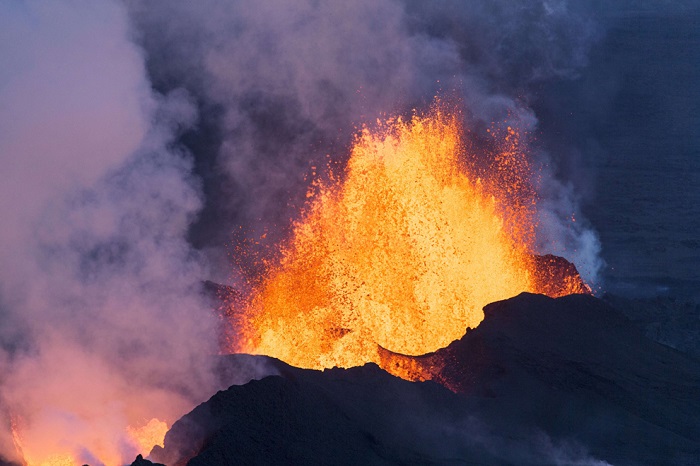
10. Panoramic view of the Ecuadorian volcano Tungurahua, which is only increasing its power. (Jose Jacome/EPA): 
11. Flowing lava from the Etna volcano in southern Sicily near the city of Catania, August 13. Etna is one of the most active volcanoes in the world and is almost always in a constant state of activity. (Tiziana Fabi/AFP/Getty Images): 
12. At the end of August, on the 29th, the Tavurvur volcano reminded itself of itself in Papua New Guinea for the first time since 1994, when the city of Rabaul was destroyed. The release of ash and rocks into the air forced air traffic controllers to redirect airline flights away from the area. (Oliver Bluett/AFP/Getty Images): 
13. Solidified lava of Etna in the south of Sicily, near the city of Catania, August 14. (Tiziana Fabi/AFP/Getty Images): 
14. According to media reports, the activity of the Slamet volcano continues to increase, and residents are advised to stay away from the four-kilometer zone of the volcano. Mount Slamet, Indonesia's second largest stratovolcano, September 11, 2014. (EPA): 
15. And this is the Indonesian Slamet on September 12th. (Gugus Mandiri/EPA): 
16. Mount Sinabung, on the island of Sumatra, Indonesia. Tens of thousands of residents fled their homes last year due to a series of eruptions and are still unable to return. (Sutanta Aditya/AFP/Getty Images): 
17. There are about 500 volcanoes in Indonesia, 128 of which are considered active and 65 have dangerous status. This photo was taken on September 13, 2014, in an abandoned school, a year after Sinabung's 9/11 series of eruptions. In 2013, 16 people died and about 20 thousand more were forced to leave their homes. (Dedi/Sahputra/EPA): 
18. Lava flowing from the Bárðarbunga volcano in southeast Iceland (Bernard Meric/AFP/Getty Images): 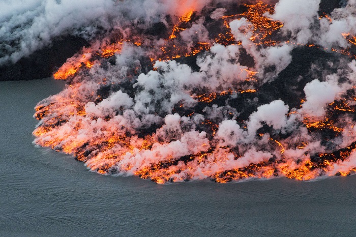
Submitting your good work to the knowledge base is easy. Use the form below
Students, graduate students, young scientists who use the knowledge base in their studies and work will be very grateful to you.
Posted on http:// www. allbest. ru/
1. Volcanic activity
2. Types of volcanic structures
3. Classification of volcanoes by shape
4. Volcanic eruption
5. Post-volcanic phenomena
6. Heat sources
7. Areas of volcanic activity
8. Volcanoes on other planets
9. Interesting facts
10. Eruptions
Literature
1. Volcanic activity
Volcanoes-- geological formations on the surface of the Earth's crust or the crust of another planet where magma comes to the surface, forming lava, volcanic gases, rocks (volcanic bombs) and pyroclastic flows.
The word "Vulcan" comes from the name of the ancient Roman god of fire, Vulcan.
The science that studies volcanoes is volcanology and geomorphology.
Volcanoes are classified by shape (shield, stratovolcanoes, cinder cones, domes), activity (active, dormant, extinct), location (terrestrial, underwater, subglacial), etc.
Volcanoes are divided depending on the degree of volcanic activity into active, dormant and extinct. An active volcano is considered to be a volcano that erupted during a historical period of time or in the Holocene. The concept of active is quite inaccurate, since a volcano with active fumaroles is classified by some scientists as active, and by others as extinct. Dormant volcanoes are considered to be inactive volcanoes where eruptions are possible, and extinct volcanoes are considered to be those where they are unlikely.
However, there is no consensus among volcanologists on how to define an active volcano. The period of volcanic activity can last from several months to several million years. Many volcanoes exhibited volcanic activity tens of thousands of years ago, but are not considered active today. Astrophysicists, from a historical perspective, believe that volcanic activity, caused, in turn, by the tidal influence of other celestial bodies, can contribute to the emergence of life. In particular, it was volcanoes that contributed to the formation of the earth’s atmosphere and hydrosphere, releasing significant amounts of carbon dioxide and water vapor; scientists also note that too active volcanism, such as on Jupiter’s moon Io, can make the planet’s surface uninhabitable. At the same time, weak tectonic activity leads to the disappearance of carbon dioxide and sterilization of the planet. “These two cases represent potential boundaries for planetary habitability and exist alongside the traditional parameters of habitable zones for systems of low-mass main sequence stars,” the scientists write.
2. Types of volcanic structures
volcano activity shield cinder
In general, volcanoes are divided into linear and central, but this division is arbitrary, since most volcanoes are confined to linear tectonic disturbances (faults) in the earth’s crust.
Linear volcanoes or fissure-type volcanoes have extensive supply channels associated with a deep split in the crust. As a rule, basaltic liquid magma flows out of such cracks, which, spreading to the sides, forms large lava covers. Along the cracks, gentle spatter shafts, wide flat cones, and lava fields appear. If the magma has a more acidic composition (higher silicon dioxide content in the melt), linear extrusive ridges and massifs are formed. When explosive eruptions occur, explosive ditches can appear tens of kilometers long.
The shapes of central-type volcanoes depend on the composition and viscosity of the magma. Hot and easily mobile basaltic magmas create vast and flat shield volcanoes (Mauna Loa, Hawaiian Islands). If a volcano periodically erupts either lava or pyroclastic material, a cone-shaped layered structure, a stratovolcano, appears. The slopes of such a volcano are usually covered with deep radial ravines - barrancos. Volcanoes of the central type can be purely lava, or formed only by volcanic products - volcanic scoria, tuffs, etc. formations, or be mixed - stratovolcanoes. There are monogenic and polygenic volcanoes. The former arose as a result of a single eruption, the latter as a result of multiple eruptions. Viscous, acidic in composition, low-temperature magma, squeezed out of the vent, forms extrusive domes (Mont Pele needle, 1902). In addition to calderas, there are also large negative relief forms associated with subsidence under the influence of the weight of erupted volcanic material and a pressure deficit at depth that arose during the unloading of the magma chamber. Such structures are called volcanotectonic depressions. Volcanotectonic depressions are very widespread and often accompany the formation of thick strata of ignimbrites - volcanic rocks of acidic composition, having different genesis. They are lava or formed by sintered or welded tuffs. They are characterized by lens-shaped segregations of volcanic glass, pumice, lava, called fiamme, and a tuff or tofo-like structure of the main mass. As a rule, large volumes of ignimbrites are associated with shallow magma chambers formed due to the melting and replacement of host rocks. Negative forms of relief associated with volcanoes of the central type are represented by calderas - large rounded failures, several kilometers in diameter.
3. Classification of volcanoes by shape
Shield volcanoes are formed as a result of repeated emissions of liquid lava (1). This shape is characteristic of volcanoes that erupt low-viscosity basaltic lava: it flows from both the central crater and the slopes of the volcano (2). Lava spreads evenly over many kilometers. Like, for example, on the Mauna Loa volcano in the Hawaiian Islands where it flows directly into the ocean.
Slag cones eject from their vent only such loose substances as stones and ash: the largest fragments accumulate in layers around the crater. Because of this, the volcano becomes higher with each eruption (1). Light particles fly away over a longer distance, which makes the slopes gentle (2).
Stratovolcanoes, or "layered volcanoes", periodically erupt lava and pyroclastic matter - a mixture of hot gas, ash and hot rocks. Therefore, deposits on their cone alternate (1). On the slopes of stratovolcanoes, ribbed corridors of solidified lava (2) are formed, which serve as support for the volcano.
Dome volcanoes are formed when granitic, viscous magma rises above the rim of a volcano's crater and only a small amount leaks out, flowing down the slopes (1). Magma clogs the volcano's crater, like a plug (2), which the gases accumulated under the dome literally knock out of the crater.
4. Volcanic eruption
Volcanic eruptions are geological emergencies that can lead to natural disasters. The eruption process can last from several hours to many years. Among the various classifications, general types stand out:
Hawaiian type- ejections of liquid basaltic lava, often forming lava lakes. should resemble scorching clouds or red-hot avalanches.
Hydroexplosive type-- eruptions that occur in shallow conditions of oceans and seas are characterized by the formation of a large amount of steam that occurs when hot magma and sea water come into contact.
5. Post-volcanic phenomena
After eruptions, when the activity of the volcano either stops forever, or it “dorms” for thousands of years, processes associated with the cooling of the magma chamber and called post-volcanic processes persist on the volcano itself and its surroundings. These include fumaroles, thermal baths, and geysers.
During eruptions, a volcanic structure sometimes collapses with the formation of a caldera - a large depression with a diameter of up to 16 km and a depth of up to 1000 m. As the magma rises, the external pressure weakens, associated gases and liquid products escape to the surface and a volcanic eruption occurs. If ancient rocks, and not magma, are brought to the surface, and the gases are dominated by water vapor formed when groundwater is heated, then such an eruption is called phreatic.
Lava that rises to the earth's surface does not always reach this surface. It only raises layers of sedimentary rocks and hardens in the form of a compact body (laccolith), forming a unique system of low mountains. In Germany, such systems include the Rhön and Eifel regions. In the latter, another post-volcanic phenomenon is observed in the form of lakes filling the craters of former volcanoes that failed to form a characteristic volcanic cone (the so-called maars).
6. Heat sources
One of the unresolved problems of volcanic activity is determining the heat source necessary for local melting of the basalt layer or mantle. Such melting must be highly localized, since the passage of seismic waves shows that the crust and upper mantle are usually in a solid state. Moreover, the thermal energy must be sufficient to melt huge volumes of solid material. For example, in the USA in the Columbia River basin (Washington and Oregon states) the volume of basalts is more than 820 thousand km?; similar large strata of basalts are found in Argentina (Patagonia), India (Deccan Plateau) and South Africa (Great Karoo Rise). Currently there are three hypotheses. Some geologists believe that the melting is caused by local high concentrations of radioactive elements, but such concentrations in nature seem unlikely; others suggest that tectonic disturbances in the form of shifts and faults are accompanied by the release of thermal energy. There is another point of view, according to which the upper mantle under conditions of high pressure is in a solid state, and when, due to fracturing, the pressure drops, it melts and liquid lava flows through the cracks.
7. Areas of volcanic activity
The main areas of volcanic activity are South America, Central America, Java, Melanesia, the Japanese Islands, the Kuril Islands, the Kamchatka Peninsula, the northwestern part of the USA, Alaska, the Hawaiian Islands, the Aleutian Islands, Iceland, and the Atlantic Ocean.
8. Volcanoes on other planets
Volcanoes are found not only on Earth, but also on other planets and their satellites. The highest mountain in the Solar System is the Martian volcano Olympus, whose height is estimated at several tens of kilometers. In the Solar System, Jupiter's satellite Io has the greatest volcanic activity. The length of the plume of erupted material reaches 300 km. On some planetary satellites, at low temperatures, it is not magma that erupts, but water and light substances. This type of eruption cannot be classified as ordinary volcanism, which is why this phenomenon is called cryovolcanism.
9. Interesting facts
In 1963, the island of Surtsey emerged as a result of the eruption of an underwater volcano off the south of Iceland.
The eruption of Mount Krakatoa in Indonesia in 1883 produced the loudest roar ever heard in history. The sound was heard at a distance of more than 4,800 km from the volcano. Atmospheric shock waves circled the Earth seven times and were still visible for 5 days. The volcano killed more than 36,000 people, razed 165 villages and damaged another 132, mostly in the form of tsunamis that followed the eruption. Volcanic eruptions after 1927 created a new volcanic island called Anak Krakatoa ("Child of Krakatoa").
Kilauea Volcano, located in the Hawaiian archipelago, is the most active volcano at present. The volcano rises only 1.2 km above sea level, but its last long eruption began in 1983 and is still ongoing. Lava flows extend 11-12 km into the ocean.
An active volcano has been discovered in Taipei, Taiwan. It was previously thought that the last volcanic activity in this area was more than 200,000 years ago, but it turned out that the last activity was only 5,000 years ago.
In 2010, the eruption of the Eyjafjallajokull volcano caused the cancellation of more than 60 thousand flights across Europe.
In 1908, in Antarctica, on Penguin Island, the village of Volcano Penguin top was founded on the top of an active volcano.
10. Eruptions
10.1. XXI century
10.2. XX century
Literature
1. M. Yampolsky. Volcano in European culture of the 18th-19th centuries. // Yampolsky M. Observer. M., 2000, p. 95-110
2. Fundamentals of Geology, N.V. Koronovsky, A.F. Yakusheva. - M.: Higher School, 1991. - P. 225-232.
3. Obruchev V.A. Fundamentals of Geology. State publishing house of geological literature. M.-L. 1947
Posted on Allbest.ru
Similar documents
Background of seismic activity. Study of seismic activity. Volcanoes and volcanic activity. Spread of volcanic activity. Volcanic danger. Earthquakes, their mechanisms and consequences, propagation of seismic waves.
course work, added 01/28/2004
Review of the structure of volcanoes in northern Kamchatka, their main parts and components. Studying the chemical composition of eruption products, identifying the centers of greatest volcanic activity. Analysis of modern methods for studying volcanic activity.
course work, added 05/17/2012
General information about volcanoes and the manifestation of volcanism. Distinctive features of active, dormant and extinct volcanoes, the reasons for their eruption, the composition of lava. Description of the most famous active volcanoes on our planet. Areas of volcanic activity.
abstract, added 04/04/2011
Main types of volcanoes. Active and extinct volcanoes. The power of the explosive awakening of a dormant volcano. Map of modern volcanism. Central and fissure volcanoes. An example of the mechanism leading to the formation of a stratovolcano. Characteristics of eruption types.
presentation, added 12/18/2013
What is a volcano, its formation process and structure. Distinctive features of active, dormant and extinct volcanoes. Causes of volcanic eruptions, composition of lava. Cycles and products of eruptions. Description of the most famous active volcanoes on the planet.
presentation, added 12/20/2010
Geysers are periodically gushing sources of hot water with steam. Geyser formation diagram. The reasons for the appearance of geysers on the surface of the Earth. History of discovery, distribution and classification of geysers, their impact on the environment and humans.
abstract, added 03/26/2012
Distribution and conditions of formation of mud volcanoes. Consideration of the structural elements and morphological characteristics of mud volcanoes. Study of the main types of mud volcanic structures. Determination of the connection between mud volcanoes and oil and gas potential.
course work, added 04/06/2018
Study of Plinian, Peleian, Strombolian, Hawaiian types of volcanic eruptions. Study of geysers as one of the manifestations of the late stages of volcanism. The emergence of lahars. Formation of specific, unique volcanogenic relief forms.
presentation, added 04/06/2015
General characteristics of volcanic eruptions: conditions, causes and mechanism of their occurrence. Geographical features of distribution and classification of volcanoes according to the chemical composition of lava. Measures to protect and reduce the consequences of eruptions.
course work, added 08/27/2012
Definition of earthquakes as powerful dynamic impacts of a tectonic nature. Behavior of soils during earthquakes and causes of destruction. Main types of seismogenic zones. Mapping seismic and volcanic activity.